Saturday, May 1, 2010

POKHARA

Pokhara

Pokhara is a remarkable place of natural beauty. Situated at an altitude of 827m from the sea level and 200km west of Kathmandu valley, the city is known as a center of adventure. The enchanting city with a

population of around 95,000 has several beautiful lakes and offers stunning panaromic views of Himalayan

peaks. The serenity of lakes and the magnificence of the Himalayas rising behind them create an ambience of peace and magic. So today the city has not only become the starting point for most popular trekking and rafting
destinations but also a place to relax and enjoy the beauty of nature.

Pokhara is part of a once vibrant trade route extending between India and Tibet. To this day, mule trains can be seen camped on the outskirts of the town, bringing goods to trade from remote regions of the Himalaya. This is the land of Magars and Gurungs, hardworking farmers and valorous warriors who have earned worldwide fame as Gurkha soldiers. The Thakalis, another important ethnic group here, are known for their entrepreneurship.

The climate of Pokhara is slightly warmer than Kathmandu with daytime temperature hovering around 15 degrees Celsius in winter and 35 degrees in summer. The monsoon season which lasts from mid-June to mid-September is very wet; in fact Pokhara records the

highest rainfall in the country. Best time to visit is between October and April.

The activities of foreign visitors to Pokhara focus around two districts known as Damside and Lakeside (or Pardi and Baidam, in Nepali, respectively). These two areas, with their strips of hotels and restaurants, are a few kilometers south-west of the main Pokhara bazaar.

 Phewa Tal (Lake)


Phewa lake, the second largest lake in the kingdom, roughly measuring 1.5 km by 4 km, is the center of all attractions in Pokhara. The enchanting lake is an idyllic playground. Brightly painted wooden boats and sailboats can be rented on reasonable cost around lakeside.

The lake is neither deep (roughly 47 meters at most) nor particulary clean, but the water is warm and swimming is pleasant if you don't think about the probable pollution.
The eastern shoreline of the lake, popularly known as Lakeside or Baidam, consists of seemingly endless strip of lodges, restaurants, bookshops and souvenir shops. One of the fascinating parts of lakeside is the splendid view of the mountains, especially when the still water reflects the peaks, creating a double image.  


Begnas lake and Rupa lake


The lakes are located about 15km from Pokhara at the end of a road that turns north from the highway to Kathmandu. Divided by the forested hillock called Panchabhaiya Danda, the lakes offer the perfect nature retreat because of their relative seclusion. Splendid boating and fishing can be done here. 


Barahi temple
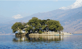
This is the most important religious monument in Pokhara. Built almost in the middle of Phewa lake, the two storied pagoda is dedicated to the boar manifestation of Ajima, the protectress deity representing the female force Shakti. Devotees can be seen, especially on Saturdays, carrying male animals and fowl across the lake to be sacrificed to the deity.  


World Peace Pagoda

The pagoda is a massive Buddhist stupa and is situated on top of a hill on the southern shore of Phewa lake. Besides being an impressive sight in itself, the shrine is a great vantage point which offers spectacular views of the Annapurna range and Pokhara city. You can get there by crossing the lake by boat and then hiking up the hill.


Seti Gandaki

Flowing right through the city, the boisterous river runs completely underground at places. Amazingly, at certain points the river appears hardly two meters wide. But its depth is quite beyond imagination - over 20 meters! Mahendra Pul, a small bridge near the old Mission Hospital, provides a perfect view of the river's dreadful rush and the deep gorge made by its powerful flow.


Devi's Fall

Locally known as Patale Chhango (Hell's Fall), Devi's fall (also known as Devin's or David's) is an awesome waterfall lying about 2 km south-west of Pokhara airport on the highway to Tansen. An interesting modern legend says that a foreigner named David was skinnydipping in the Pardi Khola (river) when the floodgates of the dam were opened, sweeping him into an underground passage beneath the fall, never to be seen again.


Gupteswar Gupha
Gupteswar Gupha, a sacred cave, lies 2 km from Pokhara airport on the Siddhartha Highway leading southwest from the city. The entrance is right across from Devi's Fall and the cave is almost 3 km long. It has some big hall-size rooms and some passages where you have to crawl on all fours. This cave holds special value for Hindus since a phallic symbol of Lord Shiva is preserved here in the condition it was discovered. An entrance fee of Rs. 5 is charged and taking pictures inside the cave is prohibited.


Mahendra Gupha

Mahendra Gufa, locally called Chamero Odhaar ("House of Bats"), is the large limestone cave. Shepherd boys are said to have discovered it around 1950. A two hour walk to the north of Pokhara, it is best to bring your own torch to see the stalactites and stalagmites, although most of them have been carted out by souvenir hunters.


The Old Bazaar

Pokhara's traditional bazaar is colorful and so are its ethnically diverse traders. In its temples and monuments can be seen ties to the Newar architecture of the Kathmandu Valley. Located about 4 km from Lakeside, the market's original charm is alive and well.


Bindbyabasini Temple

Bindhyabasini temple is the center of religious activity in the old bazaar. It is dedicated to goddess Bhagwati, yet another manifestation of shakti. Worshippers flock here to perform sacrifices, and especially on Saturdays the parklike grounds take on a festive fair.


MUSEUMS

Pokhara Museum, located between the airport and Mahendra Pul, reflects the ethnic mosaic of western Nepal. The lifestyles and history of ethnic groups such as the Gurung, Thakali and the Tharu are attractively displayed. Open daily, except Tuesdays and holidays, from 10 am to 4 pm. Entrance fee is Rs. 5 and there is an extra Rs. 10 for cameras (Tel: 0612041 3).

Annapurna Museum, also known as the Natural History Museum, is located at Prithvi Narayan Campus east of the old bazaar. Managed by the Annapurna Conservation Area Project (ACAP), the museum has an exceptional collection of butterflies, insects, birds, and models of wildlife as well as samples of various precious and semi-precious stones and volcanic rocks. Open daily, except Saturdays and holidays, from 9 am to 4 pm. Entrance is free (Tel: 061-21102).


Himalayan Vista

The magnificent Annapurna panorama that's visible on the northern skyline of Pokhara is quite incredible. The main peaks are Annapurna I to IV and the beautiful Machhapuchhare (or Fishtail Mountaian, so named after its twin peaks). Besides these, you can also see the Himchuli, Varahashikhar, Gangapurna and other peaks. The

mountains will probably be hidden in the clouds between April and September. A nice evening on the banks of Fewa Lake with the mountain range as the backdrop is what Pokhara is really about!  


Nightlife and Entertainment


There is not much of a nightlife in Pokhara other than dining. The town shuts down by about 10:30 in the evening. Until you can hang out some of the bars and pubs that are becoming trendy in the area. Fishtail Lodge puts up an hour long nightly Nepali cultural show with dances and such.


Around Pokhara
Pokhara is the starting and ending point for many of the popular trekking routes in Nepal. Longer treks (one to three week long) such as the Jomsom trek, Annapurna Circuit, and Annapurna Sanctuary begin here. Check a book on Nepal trekking for more details on this. Otherwise, you can also visit this site Pilgrims Book House for information on trekking books of Nepal.

For those with less time, Pokhara also provides shorter (one to seven days) more leisurely treks around the neighboring hills and villages. The popular ones are:

Ghachowk Trek: two days, a circuit through Lhachowk to Ghachowk and down to Batulechaur, north of Pokhara, close up view of Fishtail mountain.

Naudanda Trek: two days, to Naudanda from Suikhet and then back through Kaski, west of Pokhara.

Ghorepani Circuit: five to seven days long, upto the Gurung village of Ghandruk village, great views of the Annapurna range, north-west of Pokhara.

Kahun Danda: day trip, north east of Pokhara, 1560m altitude.

Sarangkot: day trip, great view of the mountain range including Dhaulagiri, north of Fewa Lake, 1592m altitude.

Rupa and Begnas Lakes: day trip, 15km south-east of Pokhara, take a bus there and leisurely walk along the ridge that separates the two twin lakes.


Gorkha District  


Gorkha district, a part of Gandaki zone, is one of the seventy-five districts of Nepal, a landlocked country of South Asia. The district, with Gorkha as its district headquarters, covers an area of 3,610 km² and has a population (2001) of 288,134.

The famous Manokamana temple is in the Gorkha district

A 25 kilometer road off the main highway connecting Pokhara and Kathmandu brings you to an ancient Gorkha - the untouched and captivating town of Nepal! Some 300 years ago, Nepal was divided into 50 tiny states, and Gorkha was one of them. King Prithivi Narayan Shah, the founder of `Shah Dynasty' which runs Nepal today, unified Nepal into one kingdom. His Gorkha palace resides on top of a hill at an altitude of 3281 feet (about 1000 meter) The King would watch-over his people as far as his eyes could see from the tallest palace in the very center of Nepal! Gorkha is also the home of Gurkhas - the legendary brave warriors who fought with knives against guns.

Gorkha is a picturesque hill- town that has a rich ancient history of its own. The palace is situated on a small mountain at the height of 3500 feet and offers a magnificent sightseeing of the Himalayan Peaks. King Prithvi Narayan Shah, who unified the Kingdom of Nepal during eighteenth century and got an upper hand over the Ranas, was born here. Actually king Drabya Shah founded this kingdom in the year 1560 and since then, the place has acted as the den for the Shah dynasty. In the war of throne with Ranas, the Gorkhas had the last laugh as the Gorkha soldiers succeeded in conquering the Kathmandu valley. The capital of the Nepal was shifted to Kathmandu since then. But this beautiful township has always remained as the center of attraction for many Nepalese as well as foreign visitors.

Among the sites to visit, Gorkha Durbar tops the list. This historical palace is a one-hour walk from the downtown Gorkha. The palace is strategically located over a fortified hillock. On the southwestern side of palace lies the temple of Goddess Gorakhkali. A cave that claims to shelter the statue of Gorakhnath, the Tantrik sage, adjoins it. The place is picture-perfect to have a view of Mansalu and Himalchuli peaks of Himalayas. Nevertheless, the best place to have a view of the palace and peaks is Upallokot, a viewpoint made on a pedestal over the hill at the height of some 5000 feet.


Places to Visit and Things to do in Gorkha

Gorkha Palace:

Visit the Gorkha palace here to begin your sightseeing of the region.Climb the palace steps from the bottom of the hill, all the way to the top, climbing about one thousand seven hundred steps (1700), in about two hours. That's some hiking to do! If you get tired sit down on a step or think how much easier the trip down will be! You will be glad you got to the top. On a clear sky day, you can view Himalayan range including spectacular view of Manaslu and Himalchuli Mountains, and panoramic views of the valleys.

Also view the palace building, one of Nepal's historical landmark, some buildings have interesting wood carvings portraying various romantic scenes. Also viwe the temple of Goddess Gorakhkali residing on the west side of the palace. To view sunrise from the palace, climb very early in the morning.

King Prithivi's Birthday Celebration


On King Prithivi's birthday, which is a national Nepali holiday known as Prithivi Jayanti , various celebrations are held throughout Nepal, one of which is held in Gorkha bazaar located at the foot of the hill. So if you happen to visit Gorkha on that day, observe that event as well. Prithivi Jayanti is on 27th of January 2005 (1st of Poush 2060, according to Nepalese Annual Calendar).

The King's statues are found in many places in Nepal which many visitors find of interest to observe. Many places are dedicated to his name, for example Prithivi Chok (Cross Road) in Kathmandu, Prithivi Chok in Pokhara, Prithivi Chok in Bharatpur, and the Highway connecting Kathmandu with Pokhara and then to Baglung is called Prithvi Highway. Photos and Portraits of the King have his right-hand's first finger pointing up, signifying that Nepal is one kingdom (or in Nepali, the meaning is `We all come together as one'). His statues have that characteristic.

Dashain Jamara Procession

During Nepal's popular festival Dashain, Jamaras are brought from the Gorkha palace to the modern Narayan Hiti Palace in Kathmandu. The King Prithivi Narayan Shah had moved the capital of Nepal from Gorkha to Kathmandu, and he is the founder of the Shah dynasty. Jamaras from Gorkha are used by the Royal family as a blessing from the King and above! On the Dashain Fulpati Day, there is a Royal Army parade, Fulpati procession to Gorkha Durbar and other activities of religious and cultural interests which visitors may find interesting to observe.


Popular Trekking from Gorkha

If you seek to trek from Gorkha, there is no where a better place to taste some of Nepal's hillside experience than from Gorkha. You can chose to trek from Gorkha to Kathmandu or Gorkha to Pokhara, However, the most popular trekking from Gorkha is from Gorkha to Pokhara, which is of 10 days. First day, arrive at Gorkha Bazaar, complete sightseeing of the Gorkha palace, then from the second day onwards start trekking from Gorkha - Luitel - Hirmantar - Tarughat - Besisahar - Ghattekhola - Gharpokhari - Rupatal - then arrive Pokhara on the 10th day, then extend a few days of trekking or sigtseeing in and around Pokhara.

It was said, that if anyone was seeking justice, no ruler was as fair and just as the King of Gorkha. The Gorkha kingdom was established in the year 1560, by the legendary King Drabya Shah. From the year 1604 to 1641, the Shah dynasty would become famous and rule over Gorkha. Today, the reminders of this era stand proudly in the form of the Gorkha Royal Palace, the Gorkha Bazaar and Gorkha Durbar.

The Gorkha Royal Palace was the birthplace of Prithvi Naraya, who was born in the central palace named Dhuni Pari. Prithvi Narayan Shah is known for gathering his Gorkha soldiers and battling to unify all of Nepal by taking control of the Kathmandu. After his amazing victory, in the 18th century, Kathmandu became the capital of Nepal.

To tell someone that the Gorkha Palace is located in the east side of the Gorkha Durbar would be deceiving. Most visitors are more than awestruck when they look up at the palace on the hill and the approximately one thousand seven hundred steps that lies between them and palace. The climb to the Gorkha Palace might be challenging, but the view is rewarding and the way down is a lot easier. Most of the palace remains the same as in the days of Ram Shah, but kings and rulers that followed did make a few minor changes during their reigns. Restoration work to this beautiful sight in Nepal has kept the palace in excellent condition, and although it is not always open to visitors, especially not the second floor, much can be seen through the latticed windows. The architectural style of the palace is known as Newari-style, and when peering through the windows visitors will be able to see the throne of Prithvi Narayan. Also visible is the “eternal flame” that has been burning for many years, as it was lit straight after the uniting of Nepal, at the hands of Prithvi Narayan. The detailed woodwork and spectacular carvings make the Gorkha Palace a treasured piece of history and a popular sight in Nepal.

On clear days or early mornings, the view from the palace is just short of a visual miracle of nature. The panoramic views of the rolling green landscapes, snow capped Himalayas and the town below is spectacular. From this vantage point visitors will be able to see the Goddess Gorakhkali Temple, the Himalchuli Mountain, Manaslu Mountain, Annapurna and Ganesh. It is a view and a moment in time that visitors are unlikely to forget.


Gorakhnath Cave :

Ten meters below the palace's southern side, is the sacred cave temple of Gorkhanath. The cave is is carved out of the solid rock and is among the most important religious sites for mainstream Brahmins and Chhetris of Nepal. Gorkha is also an alternate starting point for a few trekking routes in the region. Gorkha-Trisuli is an easy three day walk along unspoiled Nepali country side. One can also walk a long day's walk to Besishahar, which is the usual starting point for Annapurna and Manang area treks. One can also walk through Besishahar area to Pokhara in a four days.

Upallokot :

It is situated at a 20 minutes walking distance from Gorkha palace.There is a viewing platform at an altitude of 1520 meters in Upallokot from where the spectacular view of Gorkha palace and the sliver shining snow-fed peaks can be enjoyed.

Manakamana :

On a beautiful ridge south-east of the township of Gorkha lies the holy temple of Manakamana, the holy goddess of aspirations. It is a famous pilgrimage site for Hindus. Manakamana is 4 hour's walk uphill from Anbu Khaireni on Kathmandu-Pokhara Highway.

The new democratic constitution of the kingdom was promulgated on November 9, 1990. Nepal is one of the founder members of South Asian Association for Regional Cooperation SAARC of which the third summit was held in Kathmandu in November 1987.


LAPRAK (The Snowland Gurung village)
"LAPRAK" village is the most wonderful, heavenly and exciting, remote area of the Gorkha district. It’s a thick houses inhabited by Gurung’s .The laprak village is 125 km northwest of Kathmandu and 65 km northwest of Gorkha headquarters . 

The Gurung village is situated in the hills at an altitude of 2,300 m above the sea level .The climate is little warm and cool during the march to September and start the winter season like very cold and snow falling during the October to January end of the month .

The laprak gurung village is own their Gurung languages and culture, traditional and the houses is made by whole stone and the roof tops is covered by wood. The villagers are mainly source of independent with their agriculture and farming the land field. There are all locally produced many food items such as grain, vegetable, potato, milk, maize, barley, wheat, millet, bean others things also in this village.

The young generation youth’s are to be recruitment, regiment on soldier like uk, Singapore police, Indian army, Nepalese army also and some body has to established the trekking agency’s here in Kathmandu .


In the same time the first person of the gurung caste from western Nepal Mt Everest: late Iman Singh Gurung including 8 youth’s of they buried in the avalanche in the kangaroo himal, which add laprakies.

There is to established one higher secondary school and health post in Laprak by France peoples welfare and to facility telephone, electricity etc. The life style of the lapraki gurung village truly meditative an


meditative an exotic, strange living ethnic tradition handed down since ages.

The social life is replete, completely with interesting risible of life cycle, birth wedding, death etc. There is to live inhabit and existence only gurung peoples and kamis in Laprak. They are celebrates many festival like Buddha Jayanti, Ghatu dance ,Lhosar, tihar, Dashain, Maghesakkranti, chewarar, Ahaun, Rodhi etc as the whole gurung castes are all Buddhist religious .

The visitors to Lapraki gurung village are welcomed and respectful with offering of garlands and tika while music and dance are performed and traditional farewell songs for the guests. The people of Laprakies keep goats and sheep and use wool from these animals to make attractive products .The make cloths and bags from nettle fiber and scrafs, towels and shawls from the wool of angora Rabbits and to make of different products from the bomboo.


The lapraki gurung village is major tourist area of the Manaslu Region. There is surrounding, satellite by green forest and National flower, blossom of a plant like rhododendron and other ever green shrub also… An easy walk above the village is a view point at “Gurung Hill” pusudanda at 3000m this is the highest point south of he Gorkha .We can see many view and panorama ,magic ,mysterious and spectacular ,sunrise at the morning and many Himalayas range like Manaslu (8163m) Bouddha himal (6672m) Himalchuli (7893m) Rupina pass (4643m) Shringi Himal (7187m) ,Ganesh Himal (7429m)and Langtang Himalayas range ,Lamjung himal, Annapurna Himalayas range etc. And many visitors tourist’s are to goes from this laprak village way around the Manaslu, Larkye La pass (5213m) high altitude and the ending point place is Besishar then afterwards to goes by bus Besishar to kahtmandu . So this is a must wonderful and majestic, exicting the picture square hill town place of western part Nepal .It’s a really Spiritualism dreamland and Snowland, heaveanly of laprak Gurung village and most important Rural Tourism Sector of this Manaslu Region.

We must to be Indispensable Advertises and Publicity on different place and country about the Tourism Sector .It’s my own attitude ,advice ,counsel Dear all Guests and Visitor’s .I hopefully feeling of expectation and optimistic it’s to be great development for the Tourism Sector Our Nepal .


How to reach Gorkha?

Gorkha, located midway between Kathmandu and Pokhara, can be reached from either cities by taxi or public bus. For accommodation and dining, there are hotels, guest houses and restaurants located in Gorkha to satisfy your preferences. Transporation Cost should not cost you $2 to $3 by bus, about $20 by Taxi from Pokhara, and about $30 by Taxi from Kathmandu, and accomodation is relatively inexpensive here.


GOSAIKUNDA

GOSAIKUNDA


Gosaikunda (also spelled Gosainkunda and Gosain Kunda) is a lake in Nepal in Rasuwa district that is the site of regular Hindu pilgrimage. It is situated at the height of 4,380 metres from sea level, and melts and sips down to form the Trishuli river. It is on the way of a popular trekking route of Dhunche-Gosainkunda-Helambu trail. In fact there are 108 total lakes, small to medium in this area and also the challenging Lauribina La pass 4,610 meters on its outskirts.

Gosainkunda trek adjoins the famous Langtang trek in the same district. The lake remains frozen for six months in winter October to June. There are plenty of hotels along the route to Helambu trek.

The lake is believed to have formed from the digging of the land by the Trishul (holy three-pointed sword) of lord Shiva after he drank the poison from Samudramanthan and desperately wanted cold water to quench the overwhelming heat of the poison.


It is also one of Nepal's most famous religious places of pilgrimage is Gosainkunda lake situated at an altitude of about 4360 meters. 
The lake town is surrounded by high mountains to the north and east and the lake itself is worth the trip alone for its beauty and picturesque surroundings.

There are nine other famous lakes in the area such as Saraswati, Bhairav, Sourya and Ganesh Kunda. Every year during the Janai Purnima festival in August, thousands of Hindu and Buddhist pilgrims travel here by foot to take a holy dip in the lake.

Another site to see when traveling to Gosaikunda, besides its glacial lake, is the large rock in the center of the lake. It is said to be the remains of an ancient Shiva shrine. There is a myth that claims the lake is carried by a channel that stretches all the way from Gosaikunda in the Langtang Region to the holy pond 60 kilometers to the south at the Kumbheshwar Temple in Kathmandu's city of Patan.

The best approach to Gosainkunda for those who do not want to go trekking for too, many days, is through Dhunche. You can take a private vehichle 132 kilometers north-east of Kathmandu or take a bus (regular buses may not be scheduled) to Dhunche. Dhunche is linked with Kathmandu by a drivable yet windy road so those prone to motion sickness should take some medicine before heading to Dhunche by vehicle. You will have to trek to Gosaikunda from Dhunche which takes about two days.


LAMJUNG

LAMJUNG (STARTING POINT OF ANNAPURNA CIRCUIT TREK)


Lamjung is located at the altitude of 450 m. to 8155 m. (Manaslu) of west Nepal. Lamjung is the origin of Shah Dynasty. The old palace of shah dynasty is situated in Gaunsahar, 1-hour walk from Beshisahar capital of Lamjung District made by the King Kul Mandan Shah. The famous Goddess “Lamjung Kalika” is inside the palace. There are so many historical temples and palaces in Lamjung. The culture and festivals of Lamjung are very rich. Dura and Gurung families enjoy the “Rodhi” singing and dancing program everyday after the Dinner (meal of evening). One of the famous festivals of Nepal Ghatu: the slow and long dance related with tantrism is celebrated by Gurungs. Lamjung have famous four lakes Dudh Pokhari, Ilam Pokhari, Meme Pokhari and Barah Pokhari. The worlds famous Trekking, Annapurna Round starts from Beshisahar of Lamjung. The Annapurna area Conservation Project (ACAP) covers 1/4th (Including 8 Village Development Committees) of the total area of Lamjung. The district is inhabitants of Jharal, more than 20 types of Herbal plants, Bear, forest including different type of trees, leopard, different types of Birds, Deer, flowering and non- flowering plants, Ghoral etc. Lamjung is the most popular for visit any season on account of its position and climate. It has the most extensive views of the country’s chief attraction, the Himalayas; Annapurna (7939), Lamjung Himal (6988 m), Himal chuli (6747 m) Dhaulagiri, Machhapuchre (Fishtail), Buddha Himal (6974 m) and Gaurishankar. Well hotel accommodation is available there. It takes 6 hours from Kathmandu and 4 hours from Pokhara to reach Beshisahar by bus.

Ghalegaun Village
Ghalegaun situated at the foot of Lamjung Himal in north central Nepal, is an exotic pristine village endowed with an unparallel scenic grandeur and a home to world famous Gurkha soldiers- the Gurungs. Repository of a unique ethnic culture Ghalegaun is a true microcosm of stunning natural beauty mixed with an unspoiled ethnic lifestyle. Ghanapokhara is a beautiful village heading towards development with a concept of eco-tourism. It lies at north of Lamjung district in the close proximity of Ghalegaun at the top of Dashthar Danda at an altitude of 2100 meters. Ghalegaun and Ghanpokhara are mainly Gurung settlements; they nestle amidst mountains, rivers, streams, waterfalls and green forests. These places command a superb breathtaking view of majestic western Himalayas including Machhapuchhare(6693m) Annapurna (8091m), Annapurna II (7939m) Annapurna IV (7525m), Lamjung Himal, Bouddha Himal(6974m), Himalchuli (6747m) and many more smaller peaks. 
The approach to Ghalegaun-Ghanpokhara is a wonderful experience in itself as it goes crossing over the Marsyandi, Khudi and Midim rivers; passing through rhododendrons blossoming along the way amidst the chirping of birds and wild insects. The trekking route passes through dense jungle and villages and impressive waterfalls. Nearby Talyngo Lake and Lami Lake add new dimension to these attractions. Activities around this village including bird watching at Talangyo lake, and visitors to the Utter Kanya temple, Pempro fall, Batase cave and the Khudi hydroelectric dam site.

Ghalegaun -Ghanpokhara are model villages for experiencing the typical culture and lifestyle of the Gurung people. Traditional customs are still followed during births, deaths, marriages and at other important times in a person`s life. Age-old cultural dances like the Jhyaure, Serka, Dohori, Ghantu, Ghyabring, Krishna Charitra and Jhakri are performed on various occasions accompanied by different musical instruments with the dancers in traditional dress.
Visitors to Ghalegaun-Ghanpokhara are welcomed with offering of garlands and tika while music and dances are performed and traditional farewell songs are sung when guests depart. Nepali New Year and Buddha Jayanti are celebrated with traditional dance called Ghatu. The people of Ghalegaun-Ghanpokhara keep goats and sheep and use wool from these animals to make woolen products. They make clothes and bags from nettle fiber (allo cloth) and scarfs, towels and shawls from the wool of angora rabbits. Ironsmiths make different iron products. Craftsmen produce a whole range of different products from bamboo.

Pas gaun.
Pas gaun, the hilly village of Lamjung district magnetizes the outsiders with its beauty and hospitality of Gurung community. Small houses with stone roof and stone paved clean path makes it divine gift to the people.Tourists are pretty enjoying the nature and its beauty though there are lack of modern services and facilities due to geographical intricacy. Anyone can melt down by the warm welcome and hospitality given by gurung to the guest at Pas gaun. Pas gaun is located at one thousand six hundred and fifty meters high from sea level where 400 houses of Gurung are there. Pas gaun is reached through rural tourism village Baglungpani, Ghalegaun, Bhujung from the headquarter of Lamjung district, Besi Sahar after the 8 hours long trek. Day by day internal as well as external tourists are increasing in Pas gaun according to local social worker Balram Gurung. Comparing to other places the gurung traditional culture is still alive at Pas gaun with their uniqueness and full of entertainment. The different dances with unique dresses and folk song attract anybody over there. At Pas gaun traditional handicraft is still in practice and people use to produce different artistic bags, woolen sweater, carpets and many more. The bamboo products are also famous there.

Each and every home uses well-equipped modern toilet whereas for electrical power solar power system is connected. In each home special guest room is separated for guest at Pas gaun. After tourism ministry opened dual trekking root to reach Pas gaun people of this village are excited to bring tourist here. Different festivals are organized to renowned Pas gaun internally and internationally. According to locals almost all young bloods of this village are moving to foreign lands, if tourism activities can be increased they need not have to go abroad for job and money.

Cultural Attractions:

Ghalegaun- Ghanpokhara is a model village for experiencing the typical culture and lifestyles of the Gurung people. Traditional customs are still followed during births, deaths, marriages and in other rituals. Age old cultural dances like Jyaure, serka, dohori, Ghatu, Sorathi, Jankri etc are performed on various occasions accompanied by different musical instruments and with the dancers in traditional dress.

Ghalegaun, situated at the foot of Lamjung Himal in north central Nepal, is an exotic pristine village endowed with an unparallel scenic grandeur and a home to world famous Gurkha soldiers- the Gurungs. Repository of a unique ethnic culture Ghale gaun is a true microcosm of stunning natural beauty mixed with an unspoiled ethnic lifestyle.

Ghanapokhara is a beautiful village heading towards development with a concept of eco-tourism. It lies at north of Lamjung district in the close proximity of Ghalegaun at the top of Dashthar Danda at an altitude of 2100 meters.

Ghalegaun and Ghanpokhara are mainly Gurung settlements; they nestle amidst mountains, rivers, streams, waterfalls and green forests. These places command a superb breathtaking view of majestic western Himalayas Annapurna(8091m),

Annapurna(8091m), Annapurna II (7939m) Annapurna IV (7525m), Lamjung Himal, Bouddha Himal((6974m), Himalchuli (6747m) and many more smaller peaks. 

The approach to Ghalegaun-Ghanpokhara is a wonderful experience in itself as it goes crossing over the Marsyandi, Khudi and Midim rivers; passing through rhododendrons blossoming along the way amidst the chirping of birds and wild insects. The trekking route passes through dense jungle and villages and impressive waterfalls. Nearby Talyngo Lake and Lami Lake add new dimension to these attractions.

Activities around Ghalegaun include bird watching at Talangyo Lake and visits to the Utter Kanya Temple, Pempro Fall, Batase Cave and the Khudi hydroelectric dam site.

Home-stay With Gurungs.
Accommodation is offered at community-run home-stays in Ghalegaun and Ghanpokhara and other villages. Visitors have a chance to have a closer look at Gurung lifestyle by staying in their homes, sharing their home-cooked food and interacting with them as family guests. Food offered here is wholesome and organic, usually rice, dal, home-made buckwheat and millet bread, local vegetables and meat served with Pa (local millet alcohol). Visitors go to their allocated home for meals and to rest. Here guests are able to observe the lifestyle of the Gurungs of this region, who still follow traditional customs during birth, marriage and other important occasions. The home-stay experience is complemented by cultural shows performed by community members on request of visitors. The special feature of this village is that the Himalayas can be seen from every home.

Honey Hunting.
Hunting for honey is an age-old tradition among the people of Ghale gaun and Ghan pokhara. The local honey hunters show exceptional skills as they hang from steep cliffs as high as 300 m using bamboo ladders and hemp ropes, while harvesting the honeycombs of wild bees. The honey is harvested twice a year during April-May and October-November. Honey collected in April-May from hives on the steep cliffs is highly flavored. It is used as medicine and has a high price in the international market.


Gurung Handicrafts.
Handicrafts made in these two villages are excellent for gifts and souvenirs. The people of Ghalegaun-Ghanpokhara use the wool from their goats and sheep to make woolen products. They make clothes and bags from nettle fiber and aloe, and scarves, towels and shawls from the wool of angora rabbits. The local craftsmen make a wide range of bamboo products. The local craftsmen make traditional wooden containers Pung, Theki, Puche etc. local products from local wood called Dar.


Getting There.
Ghalegaun and Ghanpokhara are in Lamjung district of Gandaki zone. Ghalegaun is 3-4 hour trek from Khudi the gateway to the Annapurna Circuit trek. Kathmandu to Khudi is a 9-10 hour drive to Khudi via Dumre off the Kathmandu-Pokhara highway. It takes about half an hour’s uphill trek to reach Ghanpokhara from Ghalegaun. One can then continue on to Pokhara rather than retracing the route back to Khudi. One can also start the trek from Pokhara. After staying in Ghalegaun you can descend through dense forests to Khudi and drive to Beshisahar. This is the starting point for the Annapurna Circuit and an easy short¬cut to Ghalegaun via Khudi.

Tourist Services.
Houses selected for home-stay in Ghalegaun and Ghanpokhara have rooms with two beds, bathroom and toilet. There are 20 home-stays in Ghalegaun and 16 in Ghanapokhara. All programs for visitors are held in homes of the Aama Samuha (Mothers’ Group). Apart from tasting local food, other food items can be ordered from a menu. All the ingredients are local, pure and natural. Telephone service on the route is available at Pasgaun. Hiring a local guide for is recommended while going on the trek.


LUMBINI

LUMBINI

Situated at the Terai plains of the southern Nepal, Lumbini is the place where Siddhartha Gautam, the Shakya Prince and the ultimate Buddha, the Enlighted One, was born in 623 BC. The sacred place, marked by a stone pillar erected by Emperor Ashoka of India in 249 BC, is listed as one of the World Heritage Sites.


Today the holy site is being developed with international support as the supreme Buddhist pilgrimage and a symbol of world peace. The shrines and monastries that many countries have built or are still building reflect the architectural traditions of the respective countries, and thus giving Lumbini an international feel with a message of universal friendship and brotherhood.

About 30km east of Lumbini is the village of Tilaurakot which is believed to have been the location of the Kapilvastu royal palace where the Buddha grew up as the Shakya dynasty prince, until he renounced it at the age of 29 in search of enlightenment.


Of Interest

The main attraction at Lumbini remains the Sacred Garden, which is spread over 8 sq.km and possesses all the treasures of the historic area. Today as part of the global initiative to promote Lumbini, many countries have built or are building temples, monastries or stupas near the Sacred Garden in the International Monastery Zone. Temples or shrines that have finished their construction so far are Myanmar Temple, International Gautami Nuns Temple, China Temple, The Nepal Buddha Temple and the Dharma Swami Maharaja Buddha Vihara.

Ashoka pillar, carrying an inscription identifying the holy site as the birthplace, is situated nearby the Sacred Garden. To one side of Ashoka pillar is the Mayadevi Temple which houses a bas relief depicting the nativity. Recent excavations have turned up a stone bearing a "foot imprint", indicating the exact place of birth. The Puskarni pond, where Queen Mayadevi, the Buddha's mother, had taken a bath before giving birth to him lies to the south of the pillar. Kushinagar is the place where Lord Buddha passed into Mahaparinirvana. Here are a lot of chaityas, stupas and viharas to see. The Muktabandhana stupa is believed to have been built by Malla dynasty to preserve the temporal relics of Lord Buddha. A smaller shrine nearby contains a reclining Buddha which was brought from Mathura by the monk Haribala. Bodhgaya is the place where Buddha attained enlightenment. The tree under which Buddha attained wisdom is called the Bodhi tree, while the temple marking the sacred spot is known as Mahabodhi temple.

There are also three museums in Lumbini.

The Lumbini Museum

It is located in the Cultural Zone, contains Mauryan and Kushana coins, religious manuscripts, terra-cotta fragments, and stone and metal sculptures. It also possesses an extensive collection of stamps from various countries depicting Lumbini and the Buddha.


Lumbini International Research Institute (LIRI)

It is located opposite the Lumbini Museum, provides research facilities for the study of Buddhism and religion in general. Run jointly by the Lumbini Development Trust (LDT) and the Reiyukai of Japan, LIRI contains some 12,000 books on religion, philosophy, art and architecture.


Kapilvastu Museum

It is situated 27 km west of Lumbini in the village of Tilaurakot. The museum holds coins, pottery and toys dating between the seventh century BC and fourth century AD. The museum also has good collection of jwellery and other ornaments of that period.


Getting there and around


Buses run regulary after every hour or so from morning six o' clock to afternoon five o' clock to Lumbini from Bhairawa, an industrial town situated 284 km to the southeast of Lumbini. They are crowded and slow: it almost takes an hour for the 22km trip.
You can hire a cab for the day for about US$15. The cost may sound little bit expensive, but it's worth spending if you are travelling in a small group. The other option is you can hire a three-wheeler tempo for about half the price.

You can also take a 45-minute flight from Kathmandu to Gautam Buddha Airport at Bhairawa: there are five flights a week for US$75.

Depending on how long you want to stay in Lumbini, a bicycle or hiring a rickshaw would be nice to go around but not necessary (expecially for the fact that one cannot find a bike for rent easily).

Accommodation


Many just make a day trip to Lumbini from neighboring towns of Butwal, Bhairawa or Sunauli. But if you want to stay in the area, the peaceful environment of Lumbini is certainly better than those towns. The Lumbini Hokke Hotel is a spotlessly clean excellent Japanese style hotel for a rather steep price (US$80 up). The Sri-Lankan Pilgrims' Rest House is a more modest living place for about US$10; it is a little distance away from the main center of Lumbini though. The Lumbini Village Lodge is closer and provides rooms for a few dollar less, but the rooms are very basic at best.


Dining


There is very little choice. There is only one restaurant, the Lumbini Garden Restaurant, which is about ten minutes walk from the center. The Lumbini Hokke Hotel (fairly expensive) and The Sri Lankan Pilgrim' Rest House (very basic menu) are the only other choices.

Maya Devi Temple

Lumbini remained neglected for centuries. In 1895, Feuhrer, a famous German archaeologist, discovered the great pillar while wandering about the foothills of the Churia range. Further exploration and excavation of the surrounding area revealed the existence of a brick temple and a sandstone sculpture within the temple itself which depicts the scenes of the Buddha's birth.

It is pointed out by scholars that the temple of Maya Devi was constructed over the foundationsof more than one earlier temple or stupa, and that this temple was probably built on an Ashokan stupa itself. On the south of the Maya Devi temple there is the famous sacred bathing pool known as Puskarni. It is believed that Maha Devi took a bath in this pool before the delivery. By the side of the Ashoka pillar there is a river which flows southeast and is locally called the 'Ol' river. In 1996, an archaeological dig unearthed a "flawless stone" placed there by the Indian Emperor Ashoka in 249 BC to mark the precise location of the Buddha's birth more than 2,600 years ago, if authenticated, the find will put Lumbini even more prominently on the map for millions of religious pilgrims.

Recently, several beautiful shrines have been built by devotees from Buddhist countries. A visit to Lumbini, the birthplace of Buddha, is not only for spiritual enlightenment but also for solace and satisfaction that one gets in such a calm and peaceful place.

The Ashoka Pillar

Discovered by the now famous German archaeolgist Dr. Fuhrer, the pillar is the first epigraphic evidence relating to the life history of Lord Buddha and is also the most visible landmark of the garden. The historic importance of the pillar is evidenced by the inscription engraved in the pillar (in Brahmi script). It is said that the great Indian Emperor Ashok visited the site in the twentieth year of is ascendancy to the throne and as a homage to the birthplace,erected the pillar. The inscriptions in the pillar roughly translates as: Kin Piyadesi beloved of th Gods, having been anointed 20 yeas, came himself and worshipped saying Here Buddha Shakyamuni was born: And he caused to make a stone (capital) representing a horse; and he caused (this) stone pillar to be erected. Because the worshipful one was born in the village of Lumbini has been made free of taxes and recipient of wealth"


Sanctum-Sanctorum of the Birthplace


The single most important place of the Lumbini (and to the entire Buddhist world for that matter) is the stoneslab-located deep in the Sanctum sanctorum. Revealed after a hard and meticulous excavations under the three layers of ruins over the site of a famous Maya Devi temple, the stone slab foundation pinpoints the location of the original place-marking the exact spot of the birthplace of Lord Buddha.

Places around Lumbini

Kapilvastu

Located some 27 km. west of Lumbini lies the ruins of historic town of "Kapilvastu". Believed to be the capital of Shakya republic where the Lord lived and enjoyed his life until his thirteeth year, Kapilvastu has been identified with. Tilaurakot by the archaelolotists. Also, the place is believed to have been associated with different important episodes: there are ruins and mounds of old stupas and monasteries made of kiln-burnt bricks and clay-mortar. The remains are surrounded by a moat and the wall of the city are made of bricks. In fact, the city of Kapilvastu are in such a grand scale that it could be easily be visualised as a seat of high culture.

Aroarakot

About 10 km northwest of Taulihawa there is a rectangular fortified area which is popularly known as Arourakot. The fortified area is identified by the famous Indian archaeologist P.C. Mukharji as the natal town of Kanakmuni Buddha. Remains of ancient moat and brick fortification around the Kot can still be clearly located. A brick lined well is seen to the south and elevated mound towards the northwest corner.

Gotihawa

About 5 km. southwest of Taulihawa, there is a village called Gotihawa. In the village there is an Ashokan Pillar standing in a slab. The upper portion of the pillar is broken and lost and only the lower portion of the pillar 3.5m. high is still intact. Adjoining the pillar towards its northeast there is a huge stupa with successive ring of wedge shaped Mauryan bricks.

Kudan

About 2 km. southwest of Taulihawa, on the left side of the Shoratgarh Taulihawa road stands the village Kudan having a huge structural ruin with a cluster of four mounds and a tank. The mounds were excavated in 1962.

Niglihawa

About 8 km, northwest of Taulihawa, there is another site of archaelogical importance. The site has quadrangular tank surrounded by bushes, locally known as Niglisagar. On the western Bank of the tank there are two broken pieces of the Ashokan pillar, the longer one laying flat and the shorter ones stack into the ground. The pillar bears 2 peacocks on the top part and a Devanagari script inscription reading Om mani Padme Hun Ripu mallasya Chiran Jayut 1234." The shorter portion of the pillar which is partly buried in the ground measures 1.52m in length bears four lines of Ashokan inscription in the Brahmi script which roughly translates as: "King Piyadasi Beloved of the gods, after 14 years of his coronation enlarged for the second time the stupa of Buddha kanaka Muni, and after 20 years of his coronat ion he came himself and worshipped (and ) he caused (this) stone pillar to be erected:"

Sagarhawa

About 12 km. north of Taulihawa, there is a forest area called Sagarhawa. In the midst of the forest there is a huge rectangular tank which is popularly known as Lumbusagar, or a long tank. The ancient tanks ruins which were excavated and indentified by Dr. Aslois A Fuhrer as the "Palace of massacre of the Shakyas" in 1895 can still be located on the west south banks of the Sagar

Lumbini Development Project


To develop "Lumbini" as a center of International Buddhist Culture and Learning a master plan development is underway. As suggested by Mr. U-Thant. The UN secretary a master plan was prepared by Mr. Kenzo T ange, the reputed Japanese architect. The salient features of the plan are:

1 Lumbini fillage
2 Monastic enclave and
3 The Sacred Garden